
Hurricane Dorian’s forecast track continued its shift east Saturday morning, maintaining the threat to Florida’s east coast but increasing the chance the storm will spare the state a direct hit.
The 8 a.m. update from the National Hurricane Center showed the storm’s winds had strengthened to 145 miles per hour and keeps most of South Florida within the cone of uncertainty, the possible paths of the storm’s center. But the cone has been shifting seaward over the past 15 hours, with the center now remaining offshore and aimed at South Carolina.
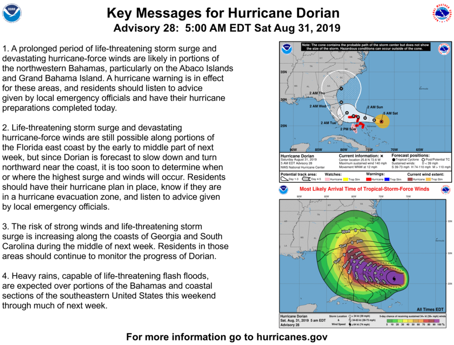
The so-called “spaghetti models,” the tangle of possible storm paths produced by various meteorological organizations, show a decisive shift toward the Atlantic, with almost all holding the storm’s core offshore until the Carolinas. Some models show no landfall at all, with the storm curling northeast into the middle of the ocean.
While that appears to be better news for South Florida, most of the state remains in the cone of uncertainty. Although the latest track excludes the Florida Keys and central Miami-Dade County, it includes Broward and all of Florida’s east coast.
A key question is how slow the storm moves. It’s expected to slow to a virtual standstill as it reaches the Bahamas, moving forward at just 2 miles per hour. The slower it goes, the more likely it is that the storm’s much-anticipated wheel to the north will take place before it reaches Florida.


If this storm follows this new path, we will be on the western edge of it. I expect a lot of wind and rain. My main concern is the trees around my apartment. Almost all of them are very tall oaks. Again, the only inside room is the downstairs half-bath that I huddled in last year. 🙄 They have just trimmed more out of the trees in the last few months. They do a pretty good job of it. I think I am as ready as I can be.
LikeLiked by 3 people
👍
LikeLike